something_random_tho

joined 1 year ago

100%. I also like to leave comments on bug fixes. Generally the more difficult the fix was to find, the longer the comment. On a couple gnarly ones we have multiple paragraphs of explanation for a single line of code.

[–] something_random_tho@lemmy.world 6 points 2 days ago (1 children)

That is 100% how it should work. No taxation without representation.

They have a concept of a plan to federate.

Plato boutta flip the table.

[–] something_random_tho@lemmy.world 11 points 1 week ago (3 children)

What are we supposed to do in warm/temperate climates, like Southern CA?

Sounds like something a Scorpio would say...

Texas vibes on this one.

Seems like a clear-cut case of voter intimidation for the FBI.

[–] something_random_tho@lemmy.world 93 points 2 weeks ago (1 children)

No, you see, it's fine now because he personally benefits from the hatred.


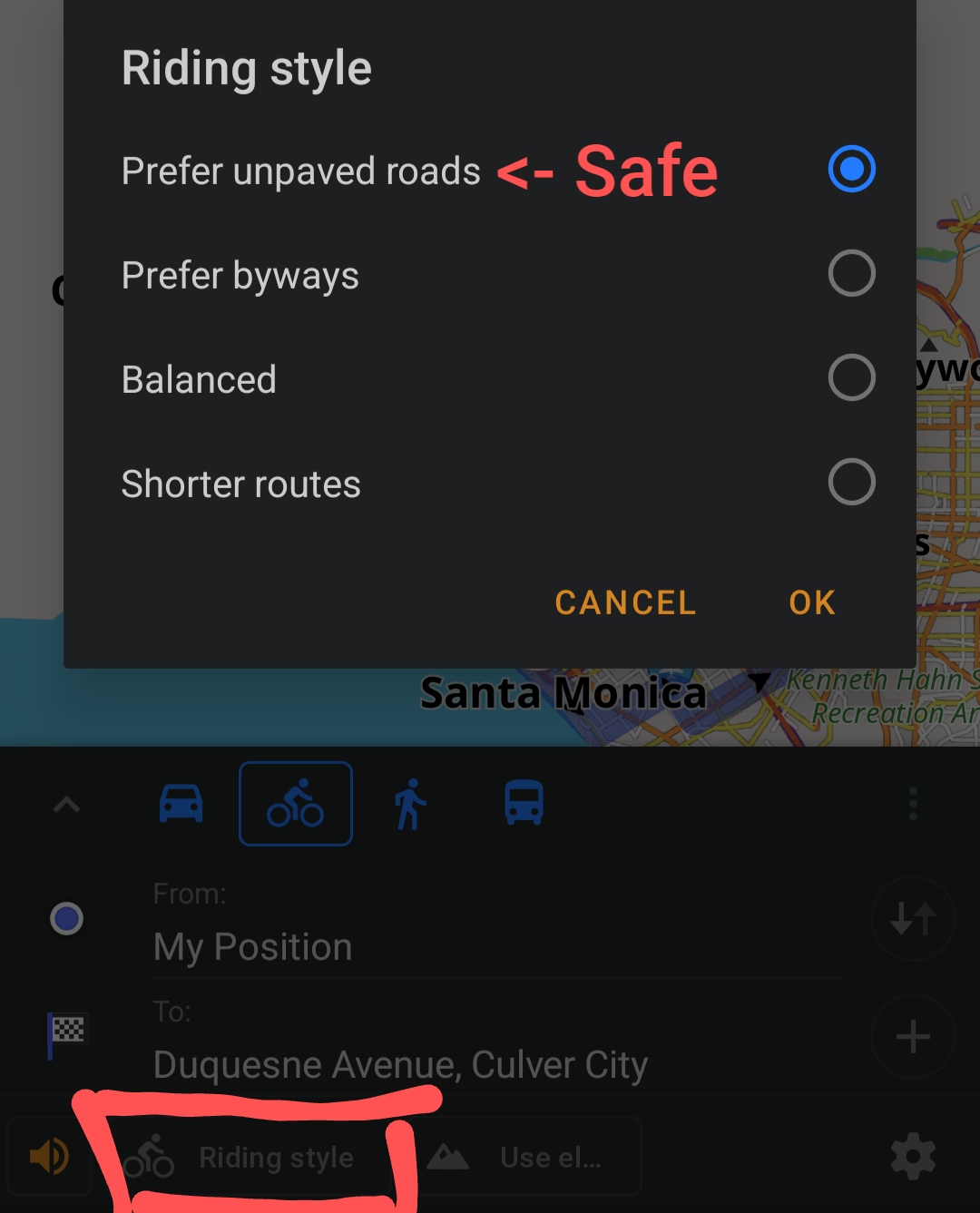
I recently found that the OsmAnd app lets you adjust the safety of your bike routes, so you can prefer safety over distance.

When navigating, click the "Ride Style" button and choose "prefer unpaved roads." That name made me think it would find gravel/off-road trails, but it actually selects safer roads. In my experience this setting chooses the optimal routes--it's finding the same general path that I would pick based on local knowledge, and it found improvements where I could take a slightly different street for a few blocks to avoid cars!

Also, OsmAnd~ is available via Fdroid with all the paywalls removed.


cross-posted from: https://lemmy.world/post/16790112

Just tried commuting on my bike from Santa Monica to downtown Culver City today. I took the Exposition bike path, which was fine until I needed to get off of it to head south.

Google recommended I take National and--lo and behold--there's no bike lane with cars flying past at 55mph+ on blind hills. That's a death trap.

On the way home I left early to avoid traffic. I took Venice Blvd, since it has a protected bike lane all the way until McLaughlin which Google Maps called "bicycle friendly." No bike lane, of course, with cars flying past leaving a foot of distance between me and death. One testy driver in a BMW didn't want to wait the 15 seconds for me to pedal into the left turn lane to get back onto the Exposition bike path, honking and then flying by nearly killing me. Jeez lady, I'm not the city planner. Don't kill me to save 15 seconds.

How does Culver City put zero bike lanes going north to south connecting to the Exposition path? How do these drivers maintain their licenses?

What's a cyclist to do?

15
submitted 3 months ago* (last edited 3 months ago) by something_random_tho@lemmy.world to c/bicycling@lemmy.world
 

Just tried commuting on my bike from Santa Monica to downtown Culver City today. I took the Exposition bike path, which was fine until I needed to get off of it to head south.

Google recommended I take National and--lo and behold--there's no bike lane with cars flying past at 55mph+ on blind hills. That's a death trap.

On the way home I left early to avoid traffic. I took Venice Blvd, since it has a protected bike lane all the way until McLaughlin which Google Maps called "bicycle friendly." No bike lane, of course, with cars flying past leaving a foot of distance between me and death. One testy driver in a BMW didn't want to wait the 15 seconds for me to pedal into the left turn lane to get back onto the Exposition bike path, honking and then flying by nearly killing me. Jeez lady, I'm not the city planner. Don't kill me to save 15 seconds.

How does Culver City put zero bike lanes going north to south connecting to the Exposition path? How do these drivers maintain their licenses?

What's a cyclist to do?

view more: next ›