1
Here we go proper in the Atlantic
(lemmy.world)
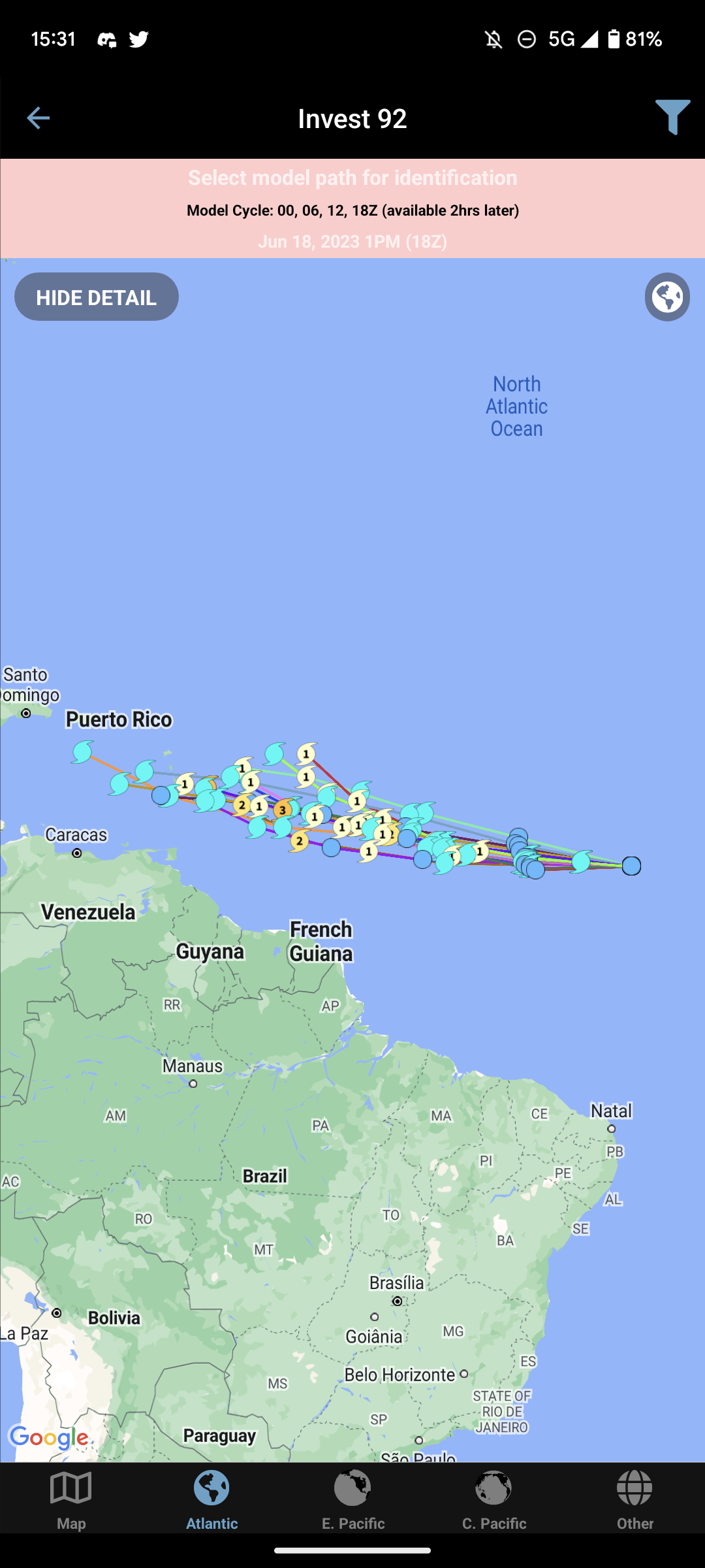
Cherry (90%) Tropical system
Basic trigonometry humor
I mean sure. Initially it looks horrid. But think about it. It's just a hardboiled egg.. there's worse things it could be
It's a pretty good alternative. A bit "janky" but it's a alpha app.
It's so close to the reddit apps It's throwing me a loop. But yeah. Other than the hot feed bug It's been 'good' for me
Hot
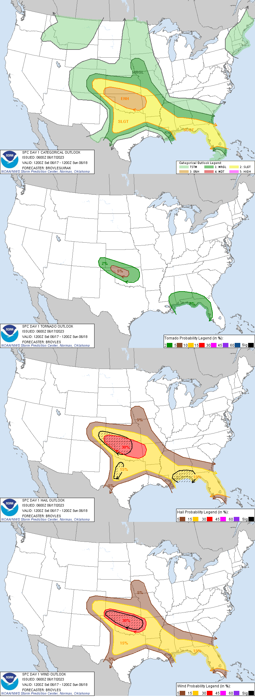
SPC AC 170600
Day 1 Convective Outlook NWS Storm Prediction Center Norman OK 0100 AM CDT Sat Jun 17 2023
Valid 171200Z - 181200Z
...THERE IS AN ENHANCED RISK OF SEVERE THUNDERSTORMS ACROSS PARTS OF THE SOUTHERN AND CENTRAL PLAINS...
...SUMMARY... Severe thunderstorms associated with damaging wind gusts and large hail are expected to develop this afternoon and evening across the southern and central Plains. Wind gusts above 70 knots and hailstones greater than 2 inches in diameter will be possible. The severe threat could reach the Ark-La-Tex after midnight. Isolated to scattered severe thunderstorms are also expected in Florida, and along parts of the central and eastern Gulf Coast.
...Central and Southern Plains... A shortwave trough will move across the southern and central Rockies today towards a moist and unstable airmass in the southern and central Plains. At the surface, a low will deepen in west Texas near a dryline that will extend northward into eastern Colorado. Low-level convergence will increase along the dryline as surface temperatures warm during the day. This should result in convective initiation in the vicinity of the Palmer Divide during the early afternoon. The convection is forecast to expand in coverage, and develop into an MCS during the late afternoon and early evening. The MCS is forecast to track east-southeastward from southeast Colorado into southern Kansas and Oklahoma.
A 45 to 60 knot mid-level jet associated with the shortwave trough, is forecast to move eastward into the southern High Plains today. Ahead of this feature, a moist and very unstable airmass will be in place form the Texas Panhandle extending east-southeastward across much of Oklahoma and northeast Texas. Surface dewpoints from the mid 60s to lower 70s F will contribute to moderate to strong instability by afternoon, with MLCAPE likely reaching the 3000 to 5000 J/kg range. In addition to an impressive thermodynamic environment, kinematics will improve during the day as the mid-level jet approaches. By late afternoon, RAP forecast soundings along the track of the expected MCS have supercell wind profiles, with 0-6 km shear around 50 knots. This, combined with 700-500 mb lapse rates near 8.0 C/km will be very favorable for large hail. Hailstones of greater than 2 inches in diameter will be possible with the more intense supercells, associated with discrete cells that develop ahead of the track of the MCS. A tornado, wind-damage and hail threat is also expected to develop with supercells embedded within the MCS. The greatest tornado threat is forecast in northwest Oklahoma, where low-level shear will steadily ramp up during the early to mid evening.
As the MCS organizes and moves southeastward into the strong instability, supercells and bowing line segments are expected. The wind-damage potential will likely increase during the early to mid evening as the MCS accelerates east-southeastward in the southern Plains. Wind gusts above 70 knots will become possible with cells near the leading edge of the MCS during the evening. The linear MCS is expected to move across central Oklahoma by late evening, and could reach the western Ozarks or Ark-La-Tex during the overnight period.
...Central and Eastern Gulf Coast into Florida... An upper-level trough will move southeastward across the eastern Gulf Coast states today. At the surface, a moist airmass will be in place from the central Gulf Coast eastward to Florida where dewpoints will be from the upper 60s to the mid 70s F. It appears that an outflow boundary will be in place in southern Mississippi and southern Alabama, where low-level convergence will become maximized during the day. As surface temperatures warm near this boundary, thunderstorms are expected to form around midday. These storms will move southeastward toward the immediate coastal areas with a severe threat likely developing. RAP forecast soundings this afternoon from Biloxi, Mississippi eastward into the Florida Panhandle have MLCAPE peaking in the 3000 to 4000 J/kg range, with steep lapse rates between 700 and 500 mb. This, combined with 0-6 km shear in the 40 to 50 knot range should support supercell development with isolated large hail. Hailstones of greater than 2 inches in diameter will be possible with the more intense cells. A wind-damage threat will also be likely.
Further east across Florida, a moist airmass will be in place with surface dewpoints in the 70s F. Thunderstorm development will take place along sea-breeze boundaries as temperatures warm during the day. A few thunderstorms will also develop further inland. RAP forecast soundings in central Florida have MLCAPE peaking around 3000 J/kg, with 0-6 m shear in the 30 to 35 knot range. This, combined with steep low-level lapse rates should be enough for an isolated wind-damage threat. Hail will also be possible with the stronger cells.
..Broyles/Jirak.. 06/17/2023
Here's our dog we got from our small town. She's the sweetest dog I have seen.
And not to worry, she's just chilling in her space. :D

Manufacturing failure modes is perhaps a weird fascination of mine. How does the industry fail for 1/1000 products sometimes...

SpaceX is now old space. They are the launch capacity of the USA. It's ridiculous actually