Screen shot from the mission map

Screen shot from the mission map
it would appear they went SW or WSW
Excellent call regarding drive direction! According to the post-drive image metadata that reports the x,y z of the rover from the last zero reset of the RMC site number. That data tells us the distances between the rover's end-of-drive location and its beginning-of-drive location was 147.24 meters west, and 51.4 meters south. So that looks very close to WSW.
We'll get a precise Lat / Long etc when the traverse map or Waypoints JSON is released. Sadly that won't be released until the JPL staff report for work in the next few hours and have checked / approved the data before releasing it :)
I was hoping they'd give those spherules a dose if LIBS, but I've not really looked at all the pre-drive images yet. I also hope that the next time they equip a rover to explore other worlds they have a modified collection strategy that besides coring, they include the ability to collect samples from the surface (small pebbles etc) so we're sure to get things like those spherules :)
Edited to correct a typo and add the z -28.14 meters (change in elevation)
See the rover's wheel tracks disappearing off to the East
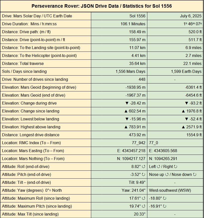
Assembled from 2 NavCam tiles after the drive on sol 1556. JPL have not yet released the drive data or the map, but it looks like a long drive down slope to the East and further away from the crater rim.
I'll post the details and map as soon as I see them

This image sees the sensor head of the Alpha-Particle X-ray Spectrometer (APXS) instrument placed on a target to acquire data. The image was taken by one of the Front Hazard Avoidance Cameras (Front HazCam) onboard NASA's Mars rover Curiosity on Sol 4590 July 5, 2025 at 11:24:54 UTC. Credits: NASA/JPL-Caltech
The APXS for MSL is an improved version of the APXS that flew successfully on Pathfinder and the Mars Exploration Rovers Spirit and Opportunity. The MSL APXS takes advantage of a combination of the terrestrial standard methods Particle-Induced X-ray Emission (PIXE) and X-ray Fluorescence (XRF) to determine elemental chemistry. It uses curium-244 sources for X-ray spectroscopy to determine the abundance of major elements down to trace elements from sodium to bromine and beyond.
The instrument consists of a main electronics unit in the rover's body and a sensor head mounted on the robotic arm. Measurements are taken by deploying the sensor head towards a desired sample, placing the sensor head in contact or hovering typically less than 2 cm away, and measuring the emitted X-ray spectrum for 15 minutes to 3 hours without the need of further interaction by the rover. At the end of the measurement, the rover retrieves the science data of 32 kilobytes, containing up to 13 consecutively taken spectra and engineering data. The internal APXS software splits the total measurement into equal time slots with an adjustable cycle time parameter. This allows us to check for repeatability and to select spectra with sufficient spectral quality.
The MSL APXS can activate an internal Peltier cooler for the X-ray detector chip. This results in a sufficient spectral resolution (FWHM) of below 200 eV at 6.4 keV below ~ -5 deg C and best FWHM of < 150 eV below ~ -15 deg C environmental temperature. Compared to the APXS on MER, where the best FWHM was reached at temperatures below ~ -45 deg C, this allows a significantly larger operational time window for APXS analysis.
The MSL APXS has approximately 3 times the sensitivity for low Z (atomic number) elements and approximately 6 times for higher Z elements than the MER APXS. A full analysis with detection limits of 100 ppm for Ni and ~ 20 ppm for Br now requires 3 hours, while quick look analysis for major and minor elements at ~ 0.5% abundance, such as Na, Mg, Al, Si, Ca, Fe, or S, can be done in 10 minutes or less.
On MER, the elements detected by the APXS in rock and soil samples are typically Na, Mg, Al, Si, P, S, Cl, K, Ca, Ti, Cr, Mn, Fe, Ni, Zn, and Br. Elevated levels of Ge, Ga, Pb, and Rb were found in some of the MER samples.
The sampled area is about 1.7 cm in diameter when the instrument is in contact with the sample. A standoff results in gradually lower intensity and an increased diameter of the measured spot. Low Z element X-rays stem from the topmost 5 microns of the sample, higher Z elements like Fe are detected from the upper ~50 microns. Sample preparation is not needed; the APXS results average the composition over the sampled area and the oxide abundances measured are renormalized to 100%. However, on MSL, a dust removal tool (brush) is available to remove loose material from a rock surface before making an APXS measurement.

15 overlapping images

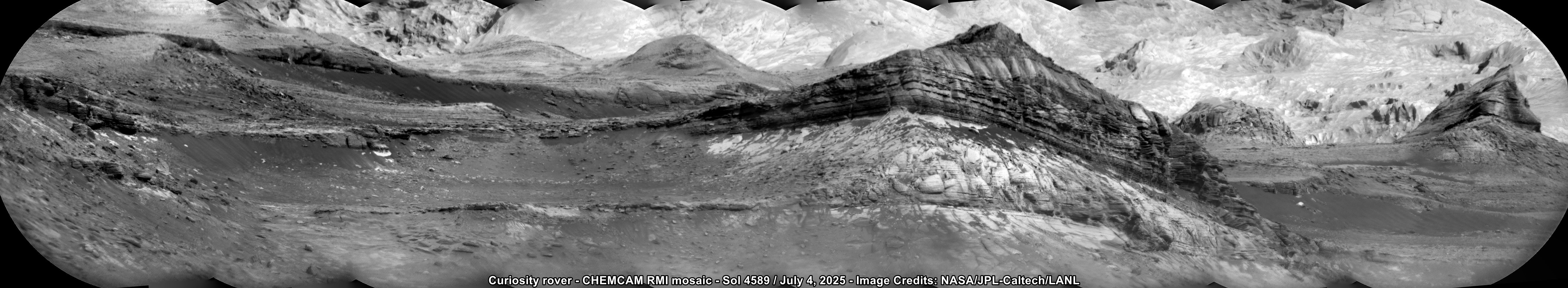
View full screen to see the diverse rock types [5506x1012px]
The mosaic is assembled from 10 overlapping RMI images from the CHEMCAM instrument, the images were acquired on Sol 4589 (July 4, 2025) and assembled in MS-ICE. Image Credits: NASA/JPL-Caltech/LANL
I'd forgot about the aim to leave the tubes unsealed. Clearly a lot of questions about the geology outside the crater that require further investigation, and with few tubes, it makes sense to be selective. With sample return not close to having a date, I guess they can afford to take their time.
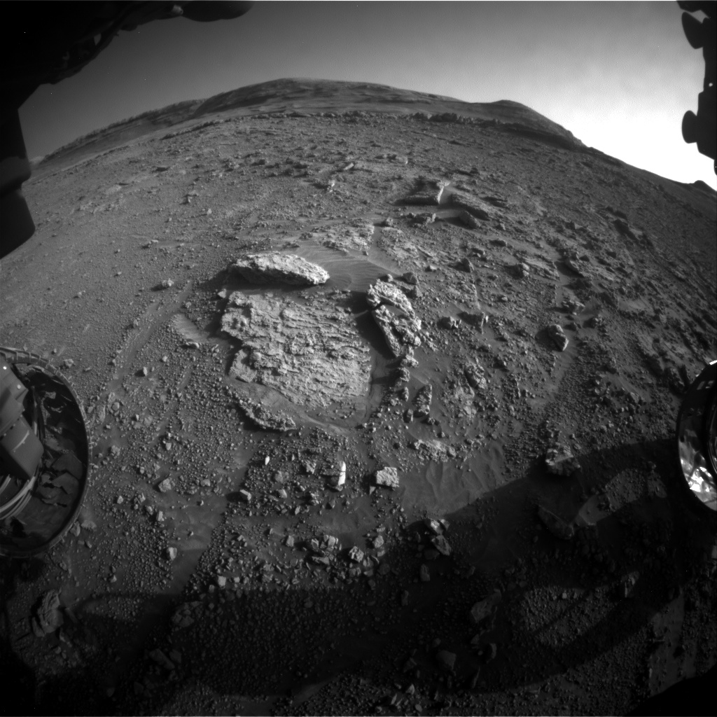
This image was taken by the Front Hazard Avoidance Camera (Front HazCam) onboard Curiosity rover on Sol 4588 (2025-07-03 09:15:59 UTC). Credits: NASA/JPL-Caltech
It shows a lighter toned rock close to the rover.
The rover is pointing Southwest after the drive to the down-slope drive of 23.4 meters (76.8 ft) towards the Northwest


NavCam mosaic (partial)

Nothing of interest to the team here as they drove away the next morning

Unfortunate that we can’t retain this small fragment when we gather the next core
I can see why they'd want to isolate cores for return to earth, but I'm sure they'd prefer to have a larger sample. Be interesting to see if they attempt to get a bigger core at this location using the same tube as it basically be the same material, maybe we'll see an attempt to shake that fragment out of the tube before trying again, or seal the sample and move on.
Have they sealed the last sample tube yet? I can't remember seeing images of it being sealed
I guess one option would be to leave this tube unsealed in the cache and decide later to stack another core on top?
Decisions decisions :) Too many choices :)
This close-up view of a plate on NASA's Perseverance rover commemorating the impact of the COVID-19 pandemic and paying tribute to the perseverance of health care workers around the world was acquired on June 28, 2025 (the 1,548th day, or sol, of its mission to Mars).
Located on the left side of the rover chassis, the 3-by-5-inch (8-by-13-centimeter) aluminum plaque was attached in May 2020 during final assembly at NASA's Kennedy Space Center in Florida.
The image was captured by the rover's WATSON (Wide Angle Topographic Sensor for Operations and eNgineering) imager, part of an instrument called SHERLOC (Scanning Habitable Environments with Raman & Luminescence for Organics & Chemicals). WATSON was built by Malin Space Science Systems (MSSS) in San Diego and is operated jointly by MSSS and NASA's Jet Propulsion Laboratory in Southern California.
Credits: NASA/JPL-Caltech/MSSS

~~As you say 'It is hard to tell', but going by the reflected light inside the tube in one of the CacheCam frame we have at this time, I'm assuming that that core fell out before it reached the imaging station inside the rover. More images needed :)~~
Update Edit after more images arrived:
Looks like I was wrong, there appears to be a small fragment in the bottom of the tube

Did this short drive really take 1 hour?
The data shows that duration.
We can usually trust this data, although the JSON data is occasionally revised and the JSON updated, after the team have checked the data, but that's rare from what I've observed.
The data is provided by JPL, in their post drive Traverse JSON URL.
That JSON reports the mission clock time in seconds (since landing).
It reports the start-of-drive (SCLK_Start) and end-of-drive (SCLK_End).
The difference between the two timestamps for this drive is 3504 seconds, or 58.4 minutes
I'm assuming the rover paused at some point during its drive although there are no mid drive images (so far), the clock keeps running during pauses for imaging or hazard avoidance.
I don't see any hazards, except for the small boulder to the side of the rover at the start of the drive. I've checked the RMC numbers on all the images we have so far from sol 1551, and I don't see any mid-drive images.
There may be some further images that are still on the rover (yet to be downlinked), so let's assume that it paused to drive around that rock (see attached pre-drive HazCam tile)

I hope I’m better at geology than poetry.
Your geology and poetry are way better than mine :)
Good one 🤣🤣🤣
I'd hazard a guess that is why they returned to this area. Yes the rock is readily fractured, but possibly better cemented than those further west and south. We'll see if they try a new abrasion or just go for a core :)
Just in case you'd missed it: You can turn parts of the map on and off on the Berlin map, eg those camera icons and the rover's current location + See this screen shot

It's a good map, very useful :)
Update - The JSON's were just released, see new post