this post was submitted on 28 Jan 2024
329 points (98.2% liked)

Map Enthusiasts

3091 readers
451 users here now

For the map enthused!

Rules:

founded 1 year ago
MODERATORS
 
top 33 comments
sorted by: hot top controversial new old
[–] ininewcrow@lemmy.ca 71 points 5 months ago (2 children)

There's a reason why indigenous people called it Mississippi, a word that came from Ojibwe and Algonquin languages, which are related.

I speak my language of Ojibwe Cree in northern Ontario and it's very clear for me to understand the word.

Mishi ... is a word we use to describe something as big in size

Sipi ... is the word for River, a major River, as opposed to a small creek or channel.

In my language and dialect, Mississippi literally translates to just 'Big River'

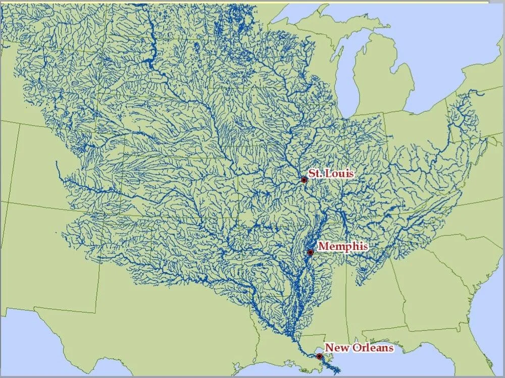
And by the look of this map .... it is definitely a 'Big River'

[–] Sunfoil@lemmy.world 14 points 5 months ago (1 children)

Big River River. This is like in the UK when the Romans arrived and asked for the names of Rivers, they were told Avon. But that's just the Celtic word for river. So we have 5 separate river Avons and they are all called River River.

[–] lars@lemmy.sdf.org 4 points 5 months ago

Naming a place just once is trash. They must be given a second name or even third appellation, and in the case of Pendleton Hill, a fourth christening.

[–] apfelwoiSchoppen@lemmy.world 59 points 5 months ago (3 children)

Louisiana is truly the US's urethra. No wonder its always so stuffy

[–] Blaze@discuss.online 11 points 5 months ago
[–] rjthyen@lemm.ee 7 points 5 months ago (1 children)

I was going to point out the OP includes the Red River which is not part of the Mississippi basin as well as a few other smaller errors. Like your post more.

[–] quicksand@lemm.ee 1 points 5 months ago

This one also includes the Red River. But I agree, I like this graphic more

[–] spicytuna62@lemmy.world 16 points 5 months ago* (last edited 5 months ago) (7 children)

It's absolutely insane we don't do a shit load more shipping in this amazing river system. Thanks, Jones Act.

The tldr is that to go directly between two ports in the United States, a ship must be American built and flying American colors. The law is the result of the shipping industry's lobbying efforts 100 years ago. Until that point, American shipping had been considered the best for several decades, and they'd rather have Uncle Sam protect them instead of doing anything to be more attractive. This is why if you get on a cruise ship, you always visit a foreign port. You can't sail directly between Houston and New York. It also means that cargo sent within the United States can't go by water. All cargo moving domestically moves by road, rail, or air.

[–] chaogomu@kbin.social 23 points 5 months ago (2 children)

The Mississippi River sees constant river boat traffic.

Those smaller, feeder rivers often aren't big enough to support a barge.

The Jones act mostly applies to ocean shipping, in fact, I don't think the Jones act even applies to river traffic.

To be fair, the Jones act consistently fucks over Puerto Rico, and should probably be scrapped or amended, it just doesn't stop river traffic on rivers that can't actually support said traffic.

[–] jayknight@lemmy.ml 4 points 5 months ago

https://www.marinetraffic.com/en/ais/home/centerx:-89.2/centery:29.1/zoom:4

You can see the traffic on the Mississippi, from downtown Memphis, you rarely see the river without some barges.

[–] apfelwoiSchoppen@lemmy.world 2 points 5 months ago* (last edited 5 months ago) (1 children)

Indeed, a lot of grain from the breadbasket of the US flows on the barges floating down the Mississippi. Much of our food system depends on that river.

The Missouri River on the other hand does not. Despite being long, it does not see much traffic due to dams and locks in Nebraska and upstream from there. Channelsizing the Missouri has proven to be difficult to maintain too. It is said that the only reason that the Missouri River is channelized is to allow Army Corp of Engineer barges up and down the river to fight the river against the channelization. A Sisyphian task.

[–] TheSanSabaSongbird@lemdro.id 3 points 5 months ago

Also it's cheaper to ship grain from the upper Missouri region to the Columbia Plateau and then down the Snake and Columbia on barges where it then gets loaded onto freighters in Portland, Vancouver and Longview and shipped to Asia and South America. By volume the Columbia is the second largest watershed in the US. Obviously all of the Columbia Plateau grain gets shipped down the Columbia as well, which is a lot, since it's a major grain producing region.

The downside is crossing the Columbia Bar which is also known as the graveyard of the Pacific, but there are highly paid Columbia River pilots for that.

[–] Neato@ttrpg.network 7 points 5 months ago

Doesn't it only have those restrictions if it's a foreign vessel? They could ship and cruise locally with American made and registered ships?

[–] JJROKCZ@lemmy.world 5 points 5 months ago (1 children)

I live in St Louis, there are tons of barges taking materials up and down the river every day. It doesn’t measure up to our hay day 130 years ago but there is still a lot of shipping

[–] TheSanSabaSongbird@lemdro.id 1 points 5 months ago

I live in Portland and it's the same here on the Columbia and the Willamette. We don't get the giant container ships because they can't cross the Columbia Bar, but we do get midsize grain ships headed for Asian and South American markets.

[–] Masterblaster@kbin.social 3 points 5 months ago

the 1800's called...

[–] JackLSauce@lemmy.world 3 points 5 months ago* (last edited 5 months ago)

Glad somebody said this

The Jones Act could be repealed tomorrow and the benefits to Hawaii, Guam, Puerto Rico, US Virgin Islands, etc would be extraordinary

[–] WarmSoda@lemm.ee 2 points 5 months ago

Which century are you talking about here?

[–] invertedspear@lemm.ee 2 points 5 months ago

I’ve been on a cruise that left LA and the first stop is in San Diego. Also don’t most Alaskan cruises go from LA to Seattle first?

[–] edgemaster72@lemmy.world 10 points 5 months ago (1 children)

Hey Michigan, we got this great big river basin, you wanna get in on this?

Michigan: NO

Michigan has a great big lake, so the water goes there instead.

[–] tallricefarmer@sopuli.xyz 8 points 5 months ago (1 children)

i guess rockies to the west and appalachia to the east means there is only one way for water shed to flow in middle north america

[–] Rhaedas@kbin.social 6 points 5 months ago* (last edited 5 months ago)

I imagine there's other connections not shown near the Great Lakes since this is just showing the dominant south paths, but for the most part it does seem that the inner continent is higher north than south. Which given the geological history also makes sense, with the Canadian shield.

[–] magnetosphere@kbin.social 6 points 5 months ago

This map is a good reminder of how insignificant international borders can be.

[–] Darkard@lemmy.world 6 points 5 months ago (1 children)

What this says to me is that most of the US is uphill from New Orleans.

[–] jayknight@lemmy.ml 8 points 5 months ago (1 children)

You certainly can't go downhill from New Orleans and stay dry.

[–] NielsBohron@lemmy.world 6 points 5 months ago

You can't even move laterally from New Orleans and remain dry

[–] Kowowow@lemmy.ca 3 points 5 months ago (2 children)

Interesting how it outlines texas pretty well(outside of the little square bit)

[–] stebo02@lemmy.dbzer0.com 9 points 5 months ago

rivers are often taken as borders, especially in Europe

[–] JPAKx4@lemmy.blahaj.zone 6 points 5 months ago

The Red River helps define the northern Texas border.

[–] xilliah@beehaw.org 1 points 5 months ago

Isn't this the river that basically bankrupted France and started the revolution? Because they thought it would be as good an investment as the Hudson River, but the area was way too swampy and so the bubble eventually burst.